Saturday, January 30, 2010

West Highland Way, Day 9: In the Footsteps of MacBeth and the Ancients

I dare do all that may become a man;
Who dares do more, is none.

- Shakespeare's Macbeth

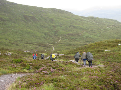
Our day started with a steep climb from the floor of Glen Leven to an old military road that will take us almost to Fort William, 15 miles from our guest house in Kinlochleven, so there will be no tarrying around today. Looking back, we had a good view of the town, Riven Leven as it emptied into Loch Leven, the huge pipes coming down the mountain from the Blackwater Reservoir and the mountains of Glencoe in the distance. The weather was a bit overcast, but not raining. Yeah! But then, this is Scotland where you never know what the day will bring.


Following the valley of the Allt Nathrach (stream of the snake), we continued up to the Lairigmore (the great pass) and ruin of an old farmhouse, Tigh-na-sleabhaich (house on the gullied slope). It was all sounding like we were on our way to Mordor. Love those Gaelic names, but I never figured out how to pronounce them like a Celt.

The Lairigmore is a long, isolated mountain pass at 1080' between high bare hills on our left and the munros of the Marmores on our right.


Beyond the Lairigmore, huge swaths of forest plantation had been clear cut leaving the mountain side bare, and we came across another of those signs about a "plant". Not even the English gentleman behind the sign with whom I had been walking for a while knew what "plant in operation" might mean. He was indignant these trees had been cut down in 2007 and no replacements yet planted. The plan was to remove plantation trees and plant native trees. Why cut all these trees and leave the mountain exposed to erosion?


A bit further on we were walking in the footsteps of Macbeth, the last Celtic king of Scotland from 1040-1057. A sign along the path said Macbeth had stayed on the crannog, an ancient artificial island made of stone and timber, in the little lake, Lochan Lunn Da-Brha. I wasn't sure whether to be more excited about Macbeth or that I finally had seen a crannog. I had been looking for one ever since Loch Lomond. I remembered Patty had said once while working on our genealogy we had an ancestor related to Macbeth. Either the crannog was a vacation home for Macbeth or he was trying to get away from some enemies, probably the latter. His stomping ground was more in eastern Scotland.


We left the military road for a path across moorland with a good view of the great Ben Nevis (mountain with its head in the clouds). The Ben is the highest of the Scottish munros and the highest mountain in Great Britain at 4406'. Many a climber has cut their teeth on this mountain before heading to the Himalaya.


The cold wind had picked up across the moorland, and we were hungry, looking for a spot to rest and refresh and finding none due to the narrowness of the track until we came to our most beautiful lunch place of the whole trip. Perhaps our rainy lunch along Loch Lomand comes a close second but this open, emerald green moorland was breathtaking. And dry!


We left the moorland for forest that would last most of the way into Fort William, the towering shape of Ben Nevis growing closer.


Through another fairy forest, and I am looking for an Iron Age fort I knew should be someplace in this area.


There are no signs or trail markers for the fort and I had no conception what an Iron Age fort might look like, but we took a trail off the path skirting the forest for about a half mile until we came to a high exposed hill.


Sure enough, climbing to the top of the hill we could see this was the fort, Dun* Deardail, one of Scotland's vitrified forts. The outside would have had a rubble wall fused by fire into a glassy matrix topped with wooden palisades on top. This photo is taken from inside the fort which is encircled by an earthen mound, and there is our Ben Nevis just beyond the mound, separated from us by the deep Glen Nevis.
* dun = gaelic for fort


I tried to think of when was the Iron Age, but all those prehistoric ages ran together in my mind. I looked it up once home; the Scotland Iron Age was about 750 BC to 500 BC. Our fort here was about 700 BC.

Standing on the top of the encircling mound, we could see down to Fort William, straight down into Glen Nevis, and we were directly facing the hulk of Ben Nevis. Seemed like a pretty defensible place to me, but we were verra chilly on this windy hill and this was July. What must it have been like in the middle of winter?


We had another four miles into Fort William but the signs of civilization were becoming evident with car parks, campgrounds, visitor centers, and finally paved road on which we were supposed to walk for the last mile or two into town. After nine days in the wilderness we weren't ready for pavement and we found a forest path detour we hoped would get us to our destination.

Our path was a bit rugged and the rain began, indeed a downpour, a fitting end to our adventure. We had walked ancient footpaths and drove roads, old military roads, farm tracks, railways, across mountains and moors, through thick forests, climbed passes, touched history, and become good buddies in the process. Next year, Patty is coming.


Our thanks to MacsAdventure whose arrangements made this self-guided trip seamless.

West Highland Way, Day 8: The Devil's Staircase

We have nine miles today, not a long walk, and we will be climbing the exposed Devil's Staircase and descending to the little Highland town of Kinlochleven. Now that we've crossed the Rannoch with weather matching the brooding moor, I'm ready for the rain to stop. Enough already. Nobody up there is listening to my petulance as we set off from Kingshouse in a light rain. The only consolation is we get to climb uphill to the highest point on the West Highland Way at the top of the Devil's Staircase.

We walked about three miles through the valley toward Glencoe before turning to ascend the Staircase, a zigzaggy trail built as a military road in 1750 as part of General Wade's plan to keep control of those rebellious Highlanders. The word is the Devil's Staircase got its name from workers who had to carry road building materials up this 1000' ascent.

The wind and cold were punishing but I had to admit the view back toward our Buachaille Etive Mor and farther to the Black Mount beside our Rannoch Moor was incredibly beautiful.


I had no room for whining about the weather. Jan was climbing with knees that measured a day's difficulty by how many Vicodin she needed.


We hung out on the col for our summit picture,


and to take in the views to the north toward the jagged ridgeline of the Mamore peaks where we were headed.


The next six miles were an easy traverse across the flanks of these high hills, then a steep descent into Kinlochleven, so we walked off into the mist.


We were in no hurry to get into Kinlochleven so Kathleen and I hung back taking pictures of the wee flowers and rock gardens of the mountain. All this rain wasn't for nothin'.


I caught one of my favorite pictures of the Port Townsend pair.


Another when they joked about Q-Tips when I asked for a picture with their hats off.


And Sally leaping a small burn*.


*burn = Scottish for stream. Here for more Scottish words.

The skies cleared briefly on our path,


and closed just as quickly, leaving us to lunch again on another wind-blown rock.


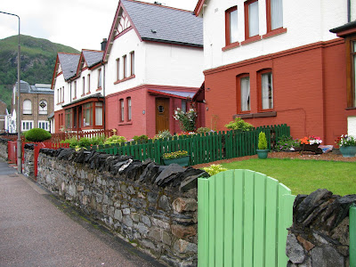
We descended through the forest of Coire Mhoraire and across River Leven into the little town of Kinlochleven. It had been an industrial town of aluminum smelting through the twentieth century, but with the smelter now gone the town has reinvented itself as a tourist center and base for outdoor enthusiasts. The town dwellers fill their yard, and I mean fill, with weird little colored statues, a lot of dwarfs, and I regret not getting any pictures of a statue filled yard.


We had a wonderfully luxurious bed and breakfast at Edencoille, also filled with all kinds of little statues and tchotchke. Kathleen and I had the attic room


with a view to these mountains, the River Leven just below the trees.


We had a wonderful and talkative - as Scots are wont to be - hostess who regaled us with tales of the West Highland Way race. Runners have 35 hours to complete what will take us nine, granted leisurely, days. The record for the race is 15 hours for men and 17 hours for women. Elsie's Royal Air Force son is one of the 544 runners who have completed the course in the last 24 years. Elsie told us of a woman who was a frequent guest and who ran the course. The lady came back to the Edencoille after finishing the race and was unable to get out of bed for the next three days and had trouble walking the next two weeks. I asked whether Elsie had taken her to a doctor and she responded, "why no, it was self-inflicted", as though this was something an American would think to do. I like that Scots attitude. Perhaps we would have less self-infliction in the world if we had to take care of the consequences by ourselves.

We made up for the short day walk - 9 miles by now is a short walk - with another couple miles to the Bothy Pub for dinner, set on the banks at the head of Loch Leven. And another Scottish beer. For Jan and me, it has been a 95 mile pub crawl and we love the end of the day beer, tonight a chance to try Three Sisters brewed here in Kinlochleven and named after the mountains of Glencoe.


Tomorrow, some ancient history and a beautiful last day.

Friday, January 22, 2010

West Highland Way, Day 7: Crossing the Rannoch Moor

The mist rose and died away, and showed us that country lying as waste as the sea; only the moor fowl and the pewees crying upon it, and far over to the east, a herd of deer, moving like dots. Much of it was red with heather; much of the rest broken up with bogs and hags and peaty pools; some had been burnt black in a heath fire; and in another place there was quite a forest of dead firs, standing like skeletons. A wearier-looking desert man never saw; but at least it was clear of troops, which was our point.

- David Balfour and Alan Brech crossing the Rannoch Moor, 1751, in Robert Louis Stevenson's Kidnapped

What a difference a day makes with this moody Scottish weather. Yesterday was dry, this morning cold, rainy, and windy, and I am excited. I have been looking forward to crossing the Rannoch ever since the kilted Mr. Montgomery in the Glasgow cathedral told me about this boggy moor with remnants of an ice age forest. Today we get to cross ten miles of this wild and desolate moor in the rain and wind, what more could a person want in life? Our guide books warn there is "no help or shelter" in the Moor. My mind's eye envisions Colin Firth riding toward us from the distance, black great coat billowing out behind, offering a hand up on his mount.

We left the comfort of our inn and skirted the west end of Lake Tulla, past campers who spent the night in a sloggy field, silently feeling grateful for our warm, dry bed the night before. We ascended on drove track through forest to the saddle in the Black Mount, that stretch of mountains that edges the moor from Glen Orchy to Glen Coe in the north, and onto the high plateau of the Rannoch Moor.


We were in one of the wildest places in Scotland, created 20,000 years ago by a glacier moving toward the east and on retreat leaving behind boulders, lochs,


hundreds of these little lochans, and a region inhospitable to humans.


Strange rivers seemed to flow from nowhere to nowhere.


I could understand why Sir Walter Scott called the MacGregors of this area "children of the mist".


It was off and on driving rain, mostly on, and only occasionally could I pull my camera out of my jacket. The reader will recall my Gore Tex boots were history left behind in Tyndrum, and my light hikers were soaked through to the metatarsals. I wore only a light hiking shirt under my rain jacket. Where was my brain when I got up this morning? Probably on Colin Firth. During one break in the rain, I turned to snap a shot of Kathleen with that ever present smile and her comments when passing by of "lovin' it".


Finding a lunch spot was not easy task. We had a choice between one exposed spot or another exposed spot, finally settling on one of those gigantic boulders dropped off by the glacier. We had walked separately most of the day. The isolation of the moor and the brooding weather were conducive to introspection and I was overwhelmed with this experience of walking one of the wonders of the earth in this perfect weather.


A couple miles from our destination Buachaille Etive Mor ("the great herdsman of Etive"), the most photographed mountain in Scotland, loomed into view.


For a short time, the weather cleared and the beautiful colors of the moor and mountain shone through.


Here is an incredible picture of the Buachaille (pronounced "Boochall", the 'ch' as in Loch) in winter.

The mountain stands guard at the junction of Glen Etive and Glen Coe and our Inn for the night sits close to the base. Kingshouse was built in the 1600's and got its name from the days after Culloden when the Duke of Cumberland used the building as barracks for his soldiers while they captured or killed any remaining Jacobites in the Highlands. I definitely did not get good vibes from this place even though the view from a lounge window is listed as one of the ten most beautiful in the world, up there with Victoria Falls.


Glen Coe extends east from our inn and I had hoped to make a visit to the beautiful valley and walk the land of the Glen Coe massacre in 1692. Thirty eight MacDonald clansmen were murdered by government soldiers under the command of a Campbell after extending their Highlander hospitality.

The visit to Glencoe would have to come another time. The weather wasn't going to let us have more sunshine and by the time we reached the Kingshouse we were in another downpour. Even so, Sally went out and walked another 2-3 miles after Jan, Kathleen and I settled in, content to take in the view out the window. That woman was on another level from us mortal walkers. Just as a warm up for the trip she had walked a 36 mile day hike - yes, day hike - in Washington mountains.


Tomorrow, we climb the Devil's Staircase.

Monday, January 18, 2010

West Highland Way, Day 6: Inveroran, A Place of Real Escape

We stocked up on lunch food at the Green Welly Shop in Tyndrum before setting off to the north through the Bridge of Orchy to Inveroran (not to be confused with Inverarnan), ten miles today but it will be three days before we come to a grocery again. We preferred to supply ourselves with cheese, crackers and fruit to eat on the trail rather than traditional lunch food. Kathleen and I had some differences about the tasteless crackers she liked, but I would count that as one of our greatest differences. Our clutch of ladies is getting on well, all mavericks that we were.

Our morning walking traversed the slopes of a munro, Ben Dorain at 3524', and a wannabe munro, Ben Odhar at 2948". I could relate to Odhar. Not so long ago, he probably met the 3000' requirement for a munro and now he was just a sub-munro. I used to be 5'4 and a half inches, now I'm 5'3 and a half.

These guys are conic mountains of volcanic origin, truly beautiful structural shapes. The big guy in the distance is Ben Dorain.


The flanks of our Bens were grazed by herds of sheep and Highland Cattle, an ancient Scottish breed that survives, even thrives under harsh conditions, much like the Highlanders themselves.


Beats me how they see past that mop top, but it must serve some survival purpose. They all seem to have the same hairdresser.


This sharp horned guy was pretty intimidating, but fortunately they seemed to be pretty even tempered animals as we had some up close and personal encounters.


In the fields just before Bridge of Orchy we came across either an antique piece of farm equipment or field sculpture. I couldn't decide which, but it looked the part.


We stopped to chat with a couple come out from the city to tend an elderly mother's house and garden, in her 80's she was and not wanting to move away from her home. I was in love with the shed. It had seen its share of hard weather, probably like its owner. It had a distressed look in furniture parlance, but naturally come by.


The hamlet of Bridge of Orchy was named after the bridge over the River Orchy built in 1751 by the government, again part of the transport project for control of those pesky Highlanders. Guide books referred to the "famous" Bridge of Orchy but I couldn't figure for what it was famous. Nothing significant happened here, no one famous lived here or did anything here. Just this beautiful old bridge, good for river watching. One of the best white water rivers in Scotland.


We lingered lunch beside the river.


As we headed up and out of Glen Orchy, I turned for a glimpse back at this peaceful little spot. I find myself doing that more often these days, at an age I know the probability I'll be back this way again is pretty small.


We crossed through a pine forest, hillsides covered with heather,


emerged onto open mountain on Mam Carraigh and scrambled up to a little cairn* to what one of Sally's guidebooks touted as the most beautiful view in Scotland, a panorama impossible to capture with a single shot, looking out over mountains, heather covered hillsides, sky, and water. Pure tranquility, and clear weather to view it all, pretty chancy in this part of Scotland, or all of Scotland for that matter.
*cairn = from Gaelic carn, a mound of stones piled up as a memorial or marker.


Looking northeast over Loch Tulla, I could see our route tomorrow crossing the small col* between Ben Toaig and Meall Beag onto Rannoch Moor, and my heart rate went up a bit. Our map and guidebooks cautioned there is no escape route or shelter crossing the moor, you are on your own, the weather is notoriously cruel, don't step off the track into the bog. Hm-m-m, just my kind of place.
*Col = a pass between mountain peaks or a break in a ridge


We hung out on our cairn a good long while with this landscape candy,


before taking the path down the mountain to Inveroran where our inn is the whole of the town.


We continued our lingering on a stone wall just a few yards from the door of the inn, as usual not wanting our walking to come to an end for the day.


The Inveroran Hotel is a rambling, narrow staired inn with eight rooms, blessedly in the middle of nowhere. The inn has been here since 1703 and, remote as it is, has had guests the likes of Samuel Taylor Coleridge, William Wordsworth and his sister Dorothy, Charles Darwin, Charles Dickens, and the great Gaelic poet Duncan Ban Macintyre who was born just down the way on the shores of Loch Tulla. The Palestinian author Raja Shehadeh writes this description of his visits to the area.

I wondered whether funky Highlander Black Watch carpeted the floors when those famous guys stayed here.


Our room faced out toward Loch Tulla,


and after leaving my bag in the room I took a walk back outdoors, catching these red deer in the back field.


Later we all took a walk - just couldn't keep off our feet - and watched the muted colors of afternoon fade into the shadows of sunset.


Tomorrow, crossing the Rannoch Moor.