We drove along Route 1 down through the lava fields to get to the South Coast. 11% of the country is covered in lava fields. A rather self-limiting factor when it comes to population growth, I would think.

We stopped for a bit in Eyrarbakki, an old trading/shipping village. The church was built in 1890; its altarpiece was painted by Queen Louise of Denmark. I was so stunned by the electric blue picket fence, however, that I didn’t notice any queenly altarpieces.

According to Wikipedia, Eyrarbakki was the main port on the south coast. A young merchant sailed in 985 AD from Eyrarbakki for Greenland, but instead reached North America. On his return trip, he landed in Greenland where he told Leif Eriksson of his discovery and sold him his boat, which Eriksson used for his own journey to North America. Today, Eyrarbakki’s primary employer is a prison, the largest in Iceland. Can’t be a very big employer, though – I read somewhere that there are no more than 200 prisoners in the whole country.

If the light was different in the pic above of Eyrarbakki’s beach, you could almost imagine you’re looking at someone’s vacation photos from the Big Island of Hawaii.
We stopped and walked up to Skógafoss, this lovely waterfall. I think the boys and Kathie ascended the stairs to the top. Lump that I am, I did not.

Volcanoes. On average, there is
a volcanic eruption every five years.
From the van, Helke pointed out Hekla in the distance, but I’ll be
honest with you – there were so many hills/mountains/glaciers in the area that
I wouldn’t be able to tell you which one was which. Hekla, however, was once believed to be the
entrance to Hell. We also passed Eyjafjallojokull,
the one that erupted in 2010 and stopped air traffic to Europe for weeks. Helke described the aftermath to us –
volcanic ash turning the day to night, etc.
Frightening, and yet the farmers still work their land there just as
they did before.

This must have been a volcano at some time.
We traveled on to Vik, where we stopped for lunch. Such a scenic place! We thought this church was maybe the one on
the cover of our guidebook, and indeed it was – although the lovely lupines on
the book had either all died or been photoshopped in.


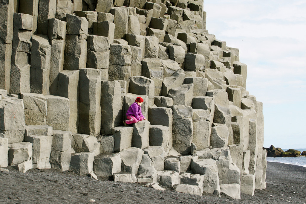
The basalt needles in the photo above can be seen from Vik. Legend has it that they were three trolls waiting to sink a ship. The two on either side of the middle one look like they maybe should have spent some more time at the gym.

Check out this cool rock formation. It’s called Dyrholaey. It reminded me of an elephant with a very, very heavy trunk. Poor guy. Can elephants get elephantiasis?
On the other side of Dyrholaey from Vik is Reynisfjara, where Helke pointed to the puffins way out in the water. There was a very cool audio effect here - the waves receding on the lava pebbles sounded a bit like going through a shell curtain. The puffins and tinkling shell curtain sound, combined with the weird rectangular rock cubes covering the slope of Reynisfjall around this sea cave (Hálsanefshellir), make this off-the-beaten-path place unforgettable.

There are so many waterfalls in Iceland, all generated from glacial meltwater. After seeing Gullfoss yesterday and Skógafoss this morning, I figured I’d seen enough. I mean, you see one waterfall, you’ve seen them all, right? At this point, we stopped at yet another one, Seljalandsfoss. Everyone, and I mean everyone, was climbing the path to get behind the waterfall. Not being one for crowds, I started to hang back but Stephen coaxed me into walking behind it. I’m glad he did because, back there, it was like looking at a sheer sparkly white curtain of tiny moving droplets. I tried to focus on one drop and trace its crashing drive to oblivion – mind-altering!

Another 11% of the country is covered in glaciers. Our last stop for the day was at a glacier. We walked up to the edge. Look at the photo below – who needs color film? There were some teens/twenty-somethings climbing up the steep face of the glacier in sneakers. One slip and someone would have been severely injured – at least. In response to Helke’s concerned call up to them, the young (overweight) man at the far left of the photo yelled back, “I’ve been doing this for 15 years”. The girls looked scared, however.

Kids. Glad they weren’t mine.
All fun days must come to an end. When we got back to Reykjavik, Kathie and I had dinner at Geysir (again) and then went home to watch CNN coverage of Hurricane Irene worrying the US’s East Coast.
3 comments:
Pat - what a treat to read your entries! I don't know if I can do as well with all the confusing names of locations. What an amazing and fascinating country. I really had a great time.
Our luck, the volcano will blow when we take our apartment there.
Joan, I am so glad you went and saw what a great place Iceland is! BTW, the Internet is great for finding the place names. :)
Kath, I think Reykjavik is pretty safe from volcanoes, isn't it?
Post a Comment